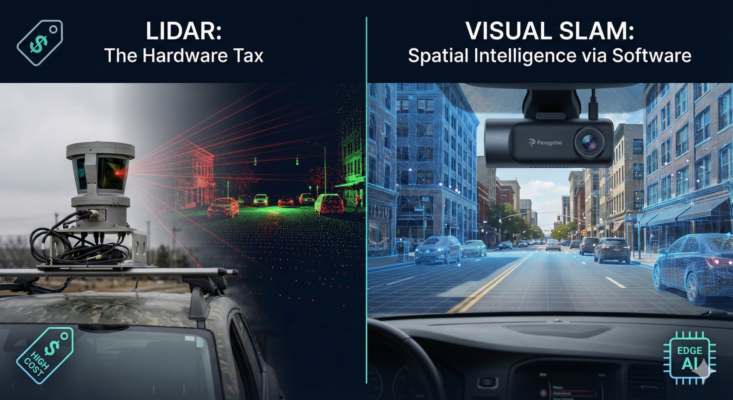
We’ve all seen the prototype vehicles outfitted with spinning laser arrays on their roofs. They are engineering marvels, spinning tens of thousands of dollars’ worth of delicate hardware to generate precise, dense point clouds of their environment. In a controlled R&D setting with unlimited budgets, LiDAR is spectacular.
But the real world doesn’t operate on unlimited budgets.
Over the past few years, speaking with leaders in logistics, telematics, and smart cities, I’ve heard the same frustration repeatedly. They want the intelligence that comes with 3D spatial awareness—knowing exactly where a vehicle is in a tunnel, mapping loading dock obstructions in real-time, or quantifying road degradation—but they cannot afford the “hardware tax” of LiDAR.
You cannot put a $5,000 sensor on a delivery van that operates on razor-thin margins. You cannot scale a technology that requires constant re-calibration if a driver hits a pothole too hard.
At Peregrine, we made a contrarian bet early on. We bet that eventually, sophisticated software running on standard, inexpensive cameras would outperform specialized, expensive hardware.
That bet has paid off. The future of spatial intelligence at scale isn’t lasers; it’s Visual SLAM powered by Edge AI.
The Magic Trick: Getting 3D Data from 2D Images
If we want machines to navigate the world like humans do, we should look at how humans do it. We don’t shoot laser beams out of our eyes to measure distance. We use passive sensors (our eyes) to take in 2D information, and a highly efficient neural network (our brain) to instantaneously translate that into a 3D understanding of the scene.
This is the essence of Visual SLAM (Simultaneous Localization and Mapping).
In simple terms, vSLAM uses camera feed(s) to map an unknown environment while simultaneously keeping track of the camera’s location within it.
Historically, this was incredibly difficult for computers. Early vSLAM struggled with varied lighting, featureless walls, or dynamic movements. But recent breakthroughs in deep learning and neural networks have fundamentally changed the game.
- Image Suggestion: A screenshot or GIF of the Peregrine “SLAM in motion” visualization (from your homepage), showing the camera path being traced through a 3D point cloud of a city street.
- Alt Text: Visual SLAM technology mapping a city street in real-time using only camera data. By training our AI models on vast amounts of diverse driving data, we have taught our software to perform tasks that previously required active sensors:
- Monocular Depth Estimation: Our AI can look at a flat, 2D image from a single standard dashcam and accurately predict the depth of every pixel in the scene, understanding relative distances just by analyzing visual context, lighting, and shadows.
- Visual Odometry: By tracking thousands of distinct “features” (like the corner of a building or a road sign) across consecutive frames, the software calculates precisely how the vehicle has moved in 3D space—even without a GPS signal.
- Dense Mapping: Instead of just sparse points, we can reconstruct dense, semantic 3D maps of the environment in real-time.
The Catalyst: Why This is Possible Now
If the math for vSLAM has existed for a while, why is it only taking off now?
The missing link was computational power at the edge.
Until recently, running complex deep learning models to turn 2D video into 3D maps required racks of servers. You couldn’t do it live in a vehicle. But the explosive improvement in the efficiency of neural networks, combined with powerful, low-energy edge processors, has closed the gap.
This is Peregrine’s core expertise. We don’t just build AI models; we optimize them ruthlessly to run on the edge. We aren’t streaming terabytes of video to the cloud to figure out where a curb is located. That processing happens in milliseconds, right on the device, inside the vehicle.
Moving Beyond Robotaxis: Real-World Applications
The beauty of shifting spatial intelligence from hardware (LiDAR) to software (vSLAM) is democratization. Suddenly, advanced perception isn’t just for million-dollar robotaxi prototypes. It’s available for the hundreds of millions of commercial vehicles already on the road.
What does this unlock today?
1. GPS-Denied Navigation
Logistics fleets operating in urban canyons, tunnels, or massive warehouse interiors often lose GPS signals. Our vSLAM tech takes over seamlessly, providing precise localization based solely on visual surroundings, ensuring asset tracking never goes dark.
2. Automated Infrastructure Auditing
Cities currently spend fortunes sending crews to manually inspect roads. A garbage truck equipped with a standard camera and Peregrine’s software can automatically generate a 3D map of potholes, cracked pavement, and faded lane markings as it drives its normal route.
3. Next-Gen Telematics
We are moving beyond simple “hard braking” alerts. By understanding the 3D spatial context of a near-miss, we can tell a fleet manager why it happened, distinguishing between risky driving and defensive maneuvers.
“The future of seeing isn’t about adding more expensive eyes. It’s about building a smarter brain.”
The Verdict
LiDAR will always have niche applications in highly specialized environments. But for mass-market mobility, the war is over. The combination of cheap, reliable CMOS image sensors and increasingly brilliant Edge AI software is the winning formula.
Ready to see Visual SLAM in action?
Don’t rely on outdated hardware. Discover how Peregrine Vision transforms standard video into deep spatial insights.