EMBEDDED VISION AI · FOR TELEMATICS SERVICE PROVIDERS
Your dashcams see everything. Now make them understand it.
Trusted by leaders across the mobility value chain
Legacy cameras record crashes. They don't prevent them.

No environmental context
Log harsh events without reading weather or traffic conditions.
High false-positive rates
Trigger constant inaccurate alerts, causing driver fatigue and mistrust.
Crushing cloud costs
Streaming hours of raw, unedited video footage to the cloud drains budgets.
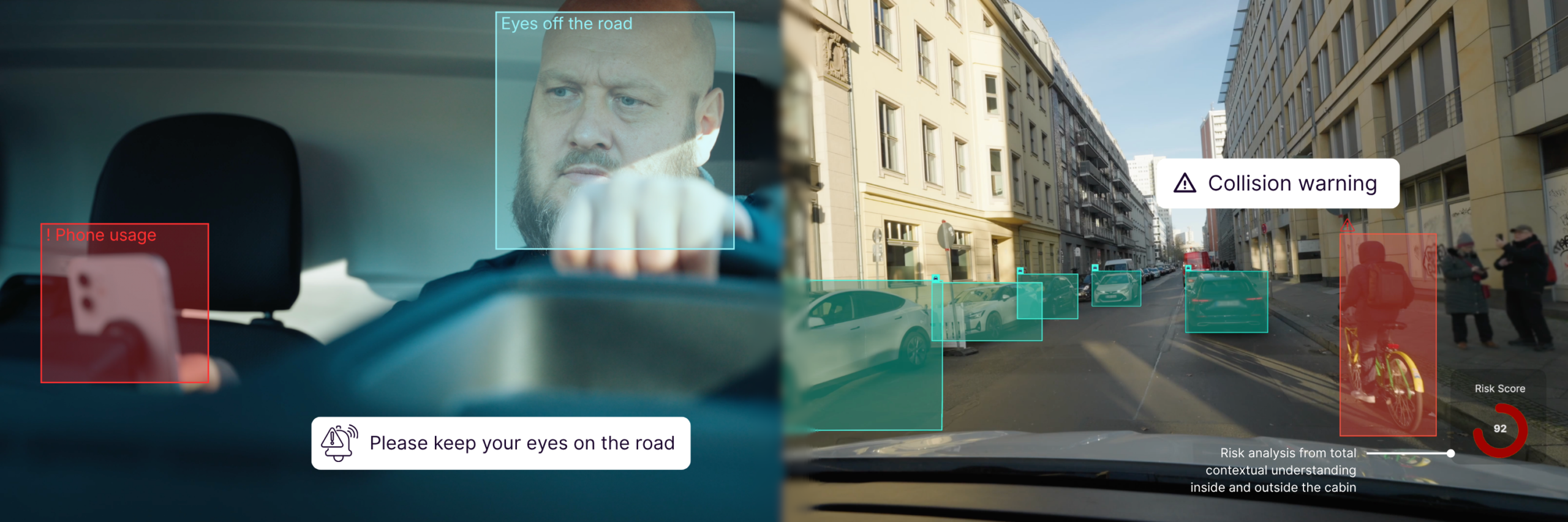
See the whole picture with Peregrine Vision
Our AI looks at the driver and the road at the same time. It clears out false alarms, cuts your cloud bills, and helps prevent crashes before they happen.
Proven results for your fleets
Vision-based safety: on the road and in the cabin
Understand risk & complexity in traffic
Our software permanently calculates a driving score, analyzing factors such as traffic density, road conditions and weather conditions. This driving score empowers fleets to preemptively address high-risk scenarios.
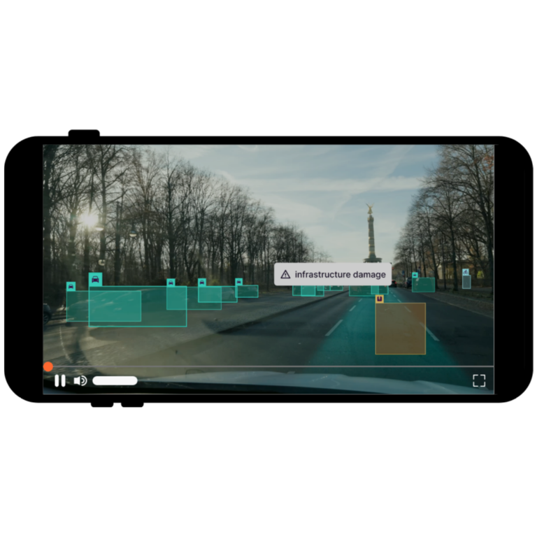
Spot & track traffic violations
Monitors compliance with traffic lights, speed limits and stop signs, identifying violations to improve fleet safety and driver accountability.
Best-in-class ADAS in telematics
Detects unsafe following distances and potential collision risks in real time, providing alerts to support drivers in preventing tailgating incidents and close-collision events.
Outward & inward facing livestreams
Access to 24/7 live video feeds. Check what’s happening on the spot.
Real-time weather & road condition monitoring
Stay ahead of changing conditions with real-time weather and road surface analysis. Detect hazards like rain, snow, fog, and slippery roads to enhance driver safety, reduce accident risks and proactively adjust routes.
Unlock new revenue streams with real-time geolocation intelligence
Our advanced SLAM technology captures high-value geospatial data, turning every mile driven into actionable insights for monetization.
Ready to be integrated on most dashcams
Easy, plug and play API integration into your dashboard. Explore our current ready-to-ship integration ecosystem below.
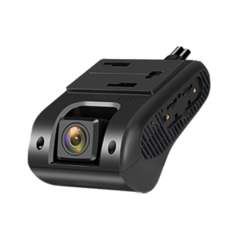
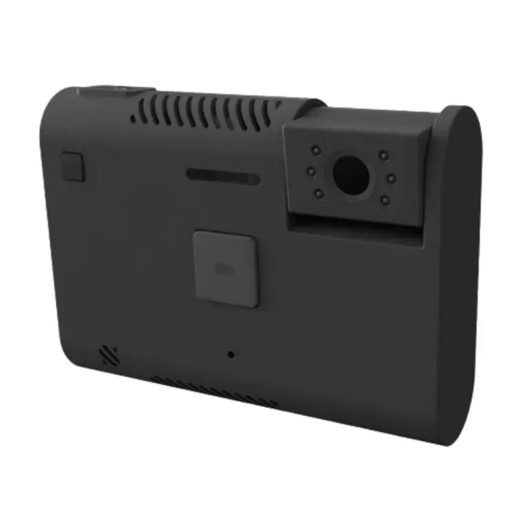
Jimi JC261
Fast, versatile connected deployment with crash detection
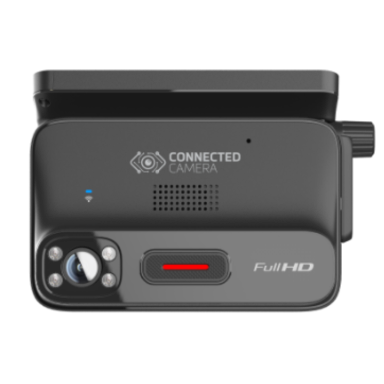
MiTAC K220
High-volume edge efficiency for last-mile delivery
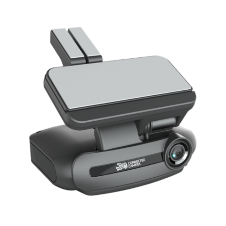
MiTAC K265
Premium multi-camera processing for long-haul
Peregrine One
Flexible APIs for custom, non-standard devices.
Android Automotive
Software-native integration built directly into next-gen OEM vehicles.
Smartphones
Instant mobile-app deployment for flexible BYOD fleet operations.
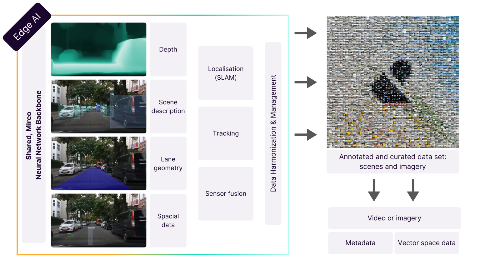
Peregrine Vision: AI for the real world, from edge to cloud.
At the heart of Peregrine Vision is artificial intelligence designed to transform cameras into smart perception systems. Combining advanced neural networks, edge processing, and adaptive learning, our proprietary AI models and data infrastructure deliver results you can trust.
Data privacy is our priority
Video data contains personal information such as faces and license plates. Peregrine’s technology automatically anonymizes information at the petabyte scale before storing traffic scenes. This differentiates our technology from common dashcams or other video solutions.


Frequently asked questions about Peregrine Vision
What types of data can Peregrine Vision capture beyond video?
Peregrine Vision captures more than just video footage. Our system collects geospatial metadata, vehicle dynamics, environmental context, and event-based triggers such as road conditions, traffic patterns, and asset locations. This multi-layered data is processed to deliver actionable insights for safety, compliance, and monetization.
Can Peregrine Vision operate in low-connectivity environments?
Yes. Peregrine Vision is optimized for edge processing, meaning critical data analysis happens locally on the device, minimizing reliance on constant connectivity. When the connection is restored, the system syncs seamlessly with the cloud to update insights without data loss.
Is Peregrine Vision compatible with both commercial and consumer-grade hardware?
Absolutely. Peregrine Vision is hardware-agnostic, designed to integrate with a wide range of devices—from aftermarket dashcams to OEM-grade systems. Our flexible API allows for seamless deployment across various hardware configurations.
How does Peregrine Vision handle edge-to-cloud data transfer efficiently?
Peregrine Vision uses advanced data compression and prioritization algorithms to reduce bandwidth usage. Only the most relevant insights are transmitted to the cloud, significantly cutting down on costs and latency while maintaining data integrity.
How scalable is Peregrine Vision for large fleets?
Peregrine Vision is designed for enterprise-grade scalability. Whether you’re managing hundreds or hundreds of thousands of vehicles, our infrastructure handles data processing, storage, and insights delivery with consistent performance.
Does Peregrine Vision require additional sensors beyond cameras?
While Peregrine Vision is optimized for camera data, it can also integrate with other vehicle sensors such as GPS, IMU (Inertial Measurement Units), and CAN bus data. In fact, in most instances, it can replace the need for a GPS altogether. This multimodal approach enhances accuracy in areas like localization, driver behavior analysis, and environmental detection.
How quickly can Peregrine Vision be deployed across a fleet?
Deployment timelines vary depending on fleet size and integration complexity. However, thanks to our plug-and-play API architecture and hardware flexibility, most telematics providers can achieve full deployment within a matter of weeks, not months.
How does Peregrine Vision support data monetization for telematics providers?
Beyond safety insights, Peregrine Vision enables telematics providers to monetize geospatial data through our Data-as-a-Service (DaaS) model. This includes localized road conditions, traffic patterns, and infrastructure insights that can be sold to industries like logistics, urban planning, and navigation services.
How customizable is Peregrine Vision for specific fleet requirements?
Peregrine Vision offers modular features that can be tailored to meet specific fleet or industry needs. Telematics providers can choose from a suite of AI models, adjust event thresholds, and customize reporting formats through our API.
Does Peregrine Vision support over-the-air (OTA) updates?
Yes. Peregrine Vision supports secure over-the-air updates for firmware, software, and AI model improvements. This ensures fleets always have access to the latest features, performance enhancements, and security patches without manual intervention.
Can Peregrine Vision detect non-vehicle-related assets like pedestrians or road infrastructure?
Yes. Peregrine Vision’s advanced computer vision algorithms detect and classify a wide range of objects, including pedestrians, cyclists, traffic signs, construction zones, and other roadside infrastructure—enhancing both safety and geospatial data accuracy.